If anyone's wondering about the orbit, it's a geosynchronous but not geostationary orbit.
The geosynchronous part is so that they only need a few sats to cover their region, unlike GPS which is global and requires some 32 sats.
It's not an equatorial geostationary orbit so that receivers at higher latitudes (in Japan) will see a sat overhead instead of always over the equator. This is to deal with the "canyon" effect. Guaranteeing a bird overhead, rather than GPS's catch-as-catch-can, should definitely help signal reliability.
These will be further away than GPS, which are medium Earth orbit.
It is a Tundra orbit. Both are pretty clever, but the Molniya is more famous--being older and more used.
Molniya is cheaper, certainly, and has the interesting property of dwelling over both the United States and Russia. Tundra orbit is aggressively regional, and thus has no plausible deniability about being for local use. If you're not a Cold Warrior, however, that doesn't matter much, so we'll probably see more Tundra type systems in the future. Europe would benefit from this exact system, as would the US. China perhaps, too.
I looks like the satellites will move much faster and lower over Australia, so they will only be overhead for shorter periods. I guess they could still be used for extra accuracy when one happens to pass by.
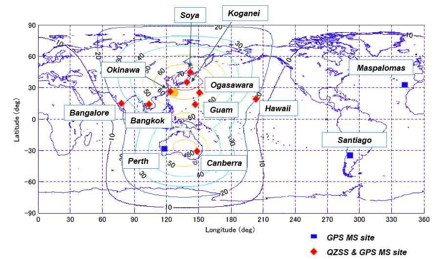
There's one in Canberra, as well as Guam, Hawaii, and Bangalore. I don't know if they're Japanese per se; "joint" is probably better. The US territory ones are NOAA or NASA in collaboration with JAXA.
Dunno if those will help with the "centimeter resolution" bit, but it'll certainly augment GPS.
The dwell over Australia and other non-Japan areas for the non-stationary sats will be shorter, but still will be useful while they are visible. And outside of "canyon" areas that will be quite often. The geostationary sats will be useful over quite a lot of the west Pacific and east Indian oceans.
Very interesting. Actually, something similar happened in the US back in 2000, when Clinton turned off something called "Selective Availability" in the US. This program deliberately degraded civilian GPS signals. After SA was turned off, we went from a GPS system that was accurate to a football field-type area to one that is accurate to a tennis-court ish area.
I don't understand these units of measurement. Football-field GPS was 4 times less accurate than tennis-field GPS? your reference indicates that uncertainty was 45 meters and became 6.5 meters, one order of magnitude improvement.
To continue with mixed standards -- a tennis court measures 23.78 by 10.97 meters (78 by 36 feet, I'm surprised it hasn't been metrified). The Japanese system should be about 3 orders of magnitude more precise than tennis-court-rated GPS.
  area of an NFL football field in square meters: 5351m^2
  area of a circle of radius 45 meters: 6361.73m^2

  area of a tennis singles court in square meters: 196.7m^2
  area of a circle of radius 6.5 meters: 133m^2
This is nothing like turning SA off. SA was the intentional injection of pseudorandom data to degrade GPS accuracy in order to deny enemies accurate positioning data. This is a system of satellites launched to augment GPS signals in a certain area of the globe for advanced civilian positioning applications.
This seems to be similar to the usage of WAAS in the US (http://en.wikipedia.org/wiki/Wide_Area_Augmentation_System), just on a smaller geographic scale. One of the bigger sources of error in GPS today is due to various atmospheric effects that bend the signal and increase the signals propagation delay. A ground stations in a known position can generate correction for the errors but the farther it's from the ground station the less useful the correction is. I've seen GPS systems used in farming applications that use a local tower that can provide corrections to give a very accurate position for the local area.
Back in 1995 I wrote the mapping software for a "Tundra Tracker", this was the navigation software for a supply vehicle that could navigate in the arctic in whiteout conditions. The idea was to have someone drive a path while conditions were good, and we would then lock in all the waypoints. Rather than store all the waypoints for the path, we were able to eliminate about 99% of them with various splining algorithms.
One of our big concerns back then, though, was that US Military would degrade the SA (Selective Availability) signal - it had happened in the Gulf War, and our tracks, which were normally accurate to within 3-4 meters, went wacky and were almost 50 meters off at times.
The solution was to mount a radio antenna, have it calculate it's "True" location by averaging a couple days worth of GPS signals, and then, continually transmit the difference between a current GPS signal and it's known location. This Differential GPS let us calculate paths to within 1m of accuracy.
When I asked what prevented a military opponent from doing the same thing, I was told that the first thing in the battlefield that gets hit as a command center would be anything transmitting RF, particularly if it was believed to be for D-GPS. Also, D-GPS isn't that effective for missile tracking, as you need to get differential signals in areas outside of your zone of control.
It does seem like WAAS at first glance, but I actually think they are creating their own GPS-compatible satellites:
> To put it simply, with QZSS it is like the number of GPS satellites has been increased. Because QZSS has interoperability with GPS, the number of satellites that can transmit satellite signals at the same time is increased, which makes stable positioning possible. This also decreases the positioning errors as described. [1]
With L1 and L5 carriers on GPS now, you can definitely get down to cm-level positioning already. I think they are just launching more satellites in Japan-specific orbits so they have better, faster GPS coverage above Japan, and especially in dense cities where you need a high angle of elevation for positioning satellites.
The farming systems are more real-time kinematic GPS, which broadcast local corrections from a dedicated reference statiion. [2]
GPS is a misnomer, it should be JPS, Japan Positioning System, nothing global to see here folks. It is unfortunate that the article does not stress that this system is only useful in Japan; especially with the conclusion that many nations will be watching the results given the "range of promised applications [range of use, certainly not geographic range] and relatively low cost." That being said I am interested to see how the experiment with atomic clockless birds goes. One of the most overlooked features of GPS is time transfer.
Well, only sort of: GPS is the initialism for a specific system (and QZSS provides corrections for that particular system's satellites, among other things), not a generic term for global navigation satellite systems. Had it said "Japan’s Plan for Centimeter-Resolution GNSS", it would have been different. Europe has EGNOS, which is similar (and was recently granted €1.3 billion for upgrades), the US has WAAS, and India has something similar too [1][2].
Yes. India has GAGAN (GPS Aided Geo-Augmented Navigation)[1][2] to augment GPS accuracy, similar to EGNOS and WAAS. Apart from this, there's IRNSS (Indian Regional Navigational Satellite System)[3], which is an indigenous satellite navigation system independent of GPS.
"Well only sort of" what? Yes, "GPS is the initialism for a specific system" and G is the initial for Global. The G in GNSS is also global so I am not sure how that is any different. The article is titled "Japan's Plan for Centimeter-Resolution GPS" and then goes on to describe a system that is anything but global.
GNSS is a generic term for globally available satellite navigation system. GPS is a GNSS implemented and maintained by the USA. Japan is planning to launch thier own satellites as part of QZSS program, to augment this GPS coverage over Japan. GPS receivers in Japan can make use of these "local" sats along with American sats for more accurate positioning.
I'm having trouble understanding the practical consequences of this project.
If I would be in Japan, with a regular, GPS-tuned/understanding device, would I get better service? Or would I need a special device, that'd be able to understand GPS+"JPS"?
The part where they transmit correction data to the satellites also confuse me, if that's what they're doing; It's not the same as the United States Global Positioning Service if that'd be the case, right? For what I've understood, the GPS doesn't need a constant feeding of data from ground stations - it's ""simply"" a bunch of satellites sending out the current time from their on-board atomic clocks.
> GPS doesn't need a constant feeding of data from ground stations
This is not the case. USNO steers the clocks(4x) on the satellites. I think they do this via the AF but I have always been a little uncertain of the exact method:
  GPS time  is automatically steered  to UTC(USNO) on  a daily basis  to keep
  system time within one microsecond of UTC(USNO) modulo 1 second, but during
  the  last several  years has  been  within a  few hundred  nanoseconds. The
  rate of steer being applied is +/-1.0E-19 seconds  per second  squared.[^1]
One of the reasons for JPS's need for direct contact with ground stations is that the newer satellites do not contain the any rubidium frequency standards and use an experimental time synching system.
GPS ground updates correct for clock skew and disturbances in orbits. The Japanese system also seems to upload the differential measurements of their entire ground reference points to rebroadcast to individual receivers.
In some senses, the technique is just an augmentation/expansion of WAAS [0] to Japan (WAAS is strictly North American).
The current GPS constellation status can be seen here, Plane/Slot describes the position in orbit, SVN is the "Space Vehicle Number", "PRN" is typically the "Sattelite Number" as displayed on a GPS receiver, because it describes the "Pseudorandom number (sequence)" used to decode signals of this particular satellite. Clock is just for information what the satellite right now uses as a timebase. As of 2014-04-27
Hell yes I did. Whole point of Rubidium clocks is you dont have to correct them.
I was hoping GPS would stay up for at least 5-10 years - I assumed all they needed was periodic orbit corrections.
Well, there goes my GPS to the rescue Zombie survival plan :/. Time to learn how to read stars, or better yet - find android app that does it automagically from a picture :)
I would have done. Having once convinced myself that four satellites shouting out the (accurate) time is sufficient to locate oneself in three dimensions, I assumed that was all there is to it.
A really big problem with satellite technology are the harsh environments they go through. You're dealing with something like 10-20g's of vibration peak-to-peak on ascent, and then you subject it to the freezing colds and searing heat of space, all while doing this in vacuum.
Since those clocks need to be super precise, it's easier to have an accurate reference on the ground where everything's not getting shaken and baked to bits.
Not right away, it will just be slightly less accurate. Ignoring all other sources of errors, for extremely high precision work you still might want to correct for the relativistic difference in time between the satellite and the surface; but in a post-apocalypse setting, I don't think you'll mind the small drifts.
There's still plenty of other maintenance, like delta-v maneuvers that need to get done or the system will eventually fail. Likely within a year.
In japan, in the typical post-apocalypse setting, small drifts are indeed not a problem. Who cares if your GPS has drifted by a few centimeter? That apocalypse may have moved the country by meters.
This system will probably be useful for quickly determining what moved in an earthquake.
> For what I've understood, the GPS doesn't need a constant feeding of data from ground stations - it's ""simply"" a bunch of satellites sending out the current time from their on-board atomic clocks.
When you get a GPS fix the very first thing your handset does is download the ephemeris data. This is broadcast at regular intervals along with the location signals. This data tells you the orbital parameters of each satellite, without it you couldn't get a precise location fix because you wouldn't know where the satellites you were getting signals from were.
The GPS satellites are incapable of calculating their own ephemeris data, it needs to be uploaded from the ground. The system cannot simply reuse the same data forever because the orbits of the satellites change over time, and because the system is sensitive to very small changes a lot of higher order effects (such as radiation pressure, the non-sphericity of the Earth's geoid, and so on) come into play which are not easily calculable. Over short periods the future ephemeris are predictable within reasonable bounds of precision, so the USAF uploads 30 days worth of ephemeris data to the GPS satellites on a regular basis.
If it were no longer possible to upload that data the system would eventually become either non-functional (depending on how the satellites and individual handsets are designed) or increasingly inaccurate until no longer useful.
    > If it were no longer possible to upload that data the system
    > would eventually become either non-functional (depending on how
    > the satellites and individual handsets are designed) or
    > increasingly inaccurate until no longer useful.
If that were to happen you could just augment GPS
receivers to use more accurate ephemeris data provided from other
sources.
It is, after all, now computed on the ground and uploaded to the GPS
constellation, having it be provided by the satellites is just a
convenience, not a necessity.
This system add additional satellites that a normal GPS receiver can receive. By using different orbits they can improve reception. It also transmits on multiple frequencies that allow the effects of the atmosphere on the signal to be better calculated. It will also transmit augmentation information to improve accuracy further.
Having moved to Tokyo last year, I'm really hopeful for more accurate altitude data. Much of Tokyo is under and above ground level, and I wish the altitude data were accurate enough to determine which floor I'm on.
Perhaps Bluetooth LE and beacons will eventually allow more accurate elevation info.
Wow, I didn't know GPS technology was even capable of that accuracy. It would be interesting to see it used in augmented reality as well as the examples from the article. You could actually have shared virtual objects positioned out in the world.
If you combined cm accuracy in cell phone tracking and a armed quadcopter, and hacked the phone company, you could build a handy remote killing device.
Many countries in these days try to build their own alternative to GPS, or in this example a extension for it. This for sure makes the location mor accurate and the systems are independant from the united states.
On the other hand for instance mobile phones have to implement all these systems and this makes them much more expensive and complicated. From my point of view it would be better to build up a universal international system. Yes, and I know this is nearly undoable.
In this case, Japan's move makes sense. The satellites are placed into an orbit so that they can be seen high in the sky, which is impossible to do for all locations on the earth.
At some point, you need to break up the augmentation systems on a continent/country-wide basis so that you can optimize the satellite orbits to work for you, instead of against you.
Additionally, QZSS seems to be pretty similar to WAAS. I get the feeling it's probably the same sort of system (though I haven't taken a look), so it's likely easy to implement from a GPS chip perspective.
The geosynchronous part is so that they only need a few sats to cover their region, unlike GPS which is global and requires some 32 sats.
It's not an equatorial geostationary orbit so that receivers at higher latitudes (in Japan) will see a sat overhead instead of always over the equator. This is to deal with the "canyon" effect. Guaranteeing a bird overhead, rather than GPS's catch-as-catch-can, should definitely help signal reliability.
These will be further away than GPS, which are medium Earth orbit.
Some other info (including an animation) here:
http://global.jaxa.jp/countdown/f18/overview/orbit_e.html
It should also be useful in Australia and parts between. They will also park spare sats in geostationary equatorial orbits.
It's a bit inspired, I think, by the Molniya orbit, another technique to get long-duration high-latitude overflight:
http://en.wikipedia.org/wiki/Molniya_orbit